Paul-Edouard Sarlin
·
Daniel DeTone
·
Tsun-Yi Yang
·
Armen Avetisyan
·
Julian Straub
Tomasz Malisiewicz
·
Samuel Rota Bulo
·
Richard Newcombe
·
Peter Kontschieder
·
Vasileios Balntas
Web demo | Colab | Paper | Project Page | Video
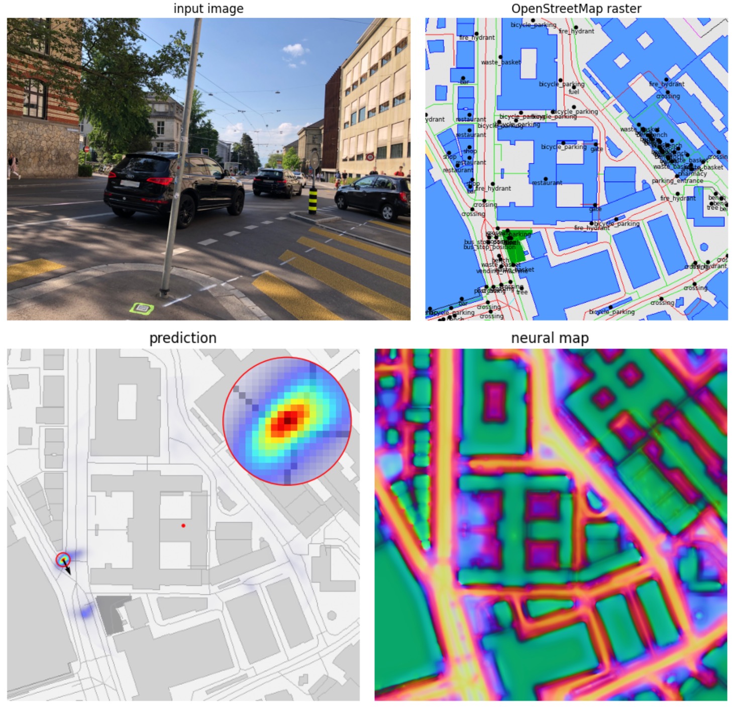
OrienterNet is a deep neural network that can accurately localize an image
using the same 2D semantic maps that humans use to orient themselves.
This repository hosts the source code for OrienterNet, a research project by Meta Reality Labs. OrienterNet leverages the power of deep learning to provide accurate positioning of images using free and globally-available maps from OpenStreetMap. As opposed to complex existing algorithms that rely on 3D point clouds, OrienterNet estimates a position and orientation by matching a neural Bird's-Eye-View with 2D maps.
OrienterNet requires Python >= 3.8 and PyTorch. To run the demo, clone this repo and install the minimal requirements:
git clone https://github.com/facebookresearch/OrienterNet
python -m pip install -r requirements/demo.txt
To run the evaluation and training, install the full requirements:
python -m pip install -r requirements/full.txtTry our minimal demo - take a picture with your phone in any city and find its exact location in a few seconds!
- Web demo with Gradio and Huggingface Spaces
- Cloud demo with Google Colab
- Local demo with Jupyter nobook
demo.ipynb

OrienterNet positions any image within a large area - try it with your own images!
[Click to expand]
To obtain the dataset:
- Create a developper account at mapillary.com and obtain a free access token.
- Run the following script to download the data from Mapillary and prepare it:
python -m maploc.data.mapillary.prepare --token $YOUR_ACCESS_TOKENBy default the data is written to the directory ./datasets/MGL/. Then run the evaluation with the pre-trained model:
python -m maploc.evaluation.mapillary --experiment OrienterNet_MGL model.num_rotations=256This downloads the pre-trained models if necessary. The results should be close to the following:
Recall xy_max_error: [14.37, 48.69, 61.7] at (1, 3, 5) m/°
Recall yaw_max_error: [20.95, 54.96, 70.17] at (1, 3, 5) m/°
This requires a GPU with 11GB of memory. If you run into OOM issues, consider reducing the number of rotations (the default is 256):
python -m maploc.evaluation.mapillary [...] model.num_rotations=128To export visualizations for the first 100 examples:
python -m maploc.evaluation.mapillary [...] --output_dir ./viz_MGL/ --num 100 To run the evaluation in sequential mode:
python -m maploc.evaluation.mapillary --experiment OrienterNet_MGL --sequential model.num_rotations=256The results should be close to the following:
Recall xy_seq_error: [29.73, 73.25, 91.17] at (1, 3, 5) m/°
Recall yaw_seq_error: [46.55, 88.3, 96.45] at (1, 3, 5) m/°
The sequential evaluation uses 10 frames by default. To increase this number, add:
python -m maploc.evaluation.mapillary [...] chunking.max_length=20[Click to expand]
- Download and prepare the dataset to
./datasets/kitti/:
python -m maploc.data.kitti.prepare- Run the evaluation with the model trained on MGL:
python -m maploc.evaluation.kitti --experiment OrienterNet_MGL model.num_rotations=256You should expect the following results:
Recall directional_error: [[50.33, 85.18, 92.73], [24.38, 56.13, 67.98]] at (1, 3, 5) m/°
Recall yaw_max_error: [29.22, 68.2, 84.49] at (1, 3, 5) m/°
You can similarly export some visual examples:
python -m maploc.evaluation.kitti [...] --output_dir ./viz_KITTI/ --num 100To run in sequential mode:
python -m maploc.evaluation.kitti --experiment OrienterNet_MGL --sequential model.num_rotations=256with results:
Recall directional_seq_error: [[81.94, 97.35, 98.67], [52.57, 95.6, 97.35]] at (1, 3, 5) m/°
Recall yaw_seq_error: [82.7, 98.63, 99.06] at (1, 3, 5) m/°
We are currently unable to release the dataset used to evaluate OrienterNet in the CVPR 2023 paper.
We trained the model on the MGL dataset using 3x 3090 GPUs (24GB VRAM each) and a total batch size of 12 for 340k iterations (about 3-4 days) with the following command:
python -m maploc.train experiment.name=OrienterNet_MGL_reproduceFeel free to use any other experiment name. Configurations are managed by Hydra and OmegaConf so any entry can be overridden from the command line. You may thus reduce the number of GPUs and the batch size via:
python -m maploc.train experiment.name=OrienterNet_MGL_reproduce \
  experiment.gpus=1 data.loading.train.batch_size=4
Be aware that this can reduce the overall performance. The checkpoints are written to ./experiments/experiment_name/. Then run the evaluation:
# the best checkpoint:
python -m maploc.evaluation.mapillary --experiment OrienterNet_MGL_reproduce
# a specific checkpoint:
python -m maploc.evaluation.mapillary \
--experiment OrienterNet_MGL_reproduce/checkpoint-step=340000.ckptTo fine-tune a trained model on the KITTI dataset:
python -m maploc.train experiment.name=OrienterNet_MGL_kitti data=kitti \
training.finetune_from_checkpoint='"experiments/OrienterNet_MGL_reproduce/checkpoint-step=340000.ckpt"'We provide several visualization notebooks:
- Visualize predictions on the MGL dataset
- Visualize predictions on the KITTI dataset
- Visualize sequential predictions
[Click to expand]
To make sure that the results are consistent over time, we used OSM data downloaded from Geofabrik in November 2021. By default, the dataset scripts maploc.data.[mapillary,kitti].prepare download pre-generated raster tiles. If you wish to use different OSM classes, you can pass --generate_tiles, which will download and use our prepared raw .osm XML files.
You may alternatively download more recent files from Geofabrik. Download either compressed XML files as .osm.bz2 or binary files .osm.pbf, which need to be converted to XML files .osm, for example using Osmium: osmium cat xx.osm.pbf -o xx.osm.
The MGL dataset is made available under the CC-BY-SA license following the data available on the Mapillary platform. The model implementation and the pre-trained weights follow a CC-BY-NC license. OpenStreetMap data is licensed under the Open Data Commons Open Database License.
Please consider citing our work if you use any code from this repo or ideas presented in the paper:
@inproceedings{sarlin2023orienternet,
  author    = {Paul-Edouard Sarlin and
               Daniel DeTone and
               Tsun-Yi Yang and
               Armen Avetisyan and
               Julian Straub and
               Tomasz Malisiewicz and
               Samuel Rota Bulo and
               Richard Newcombe and
               Peter Kontschieder and
               Vasileios Balntas},
  title     = {{OrienterNet: Visual Localization in 2D Public Maps with Neural Matching}},
  booktitle = {CVPR},
  year      = {2023},
}