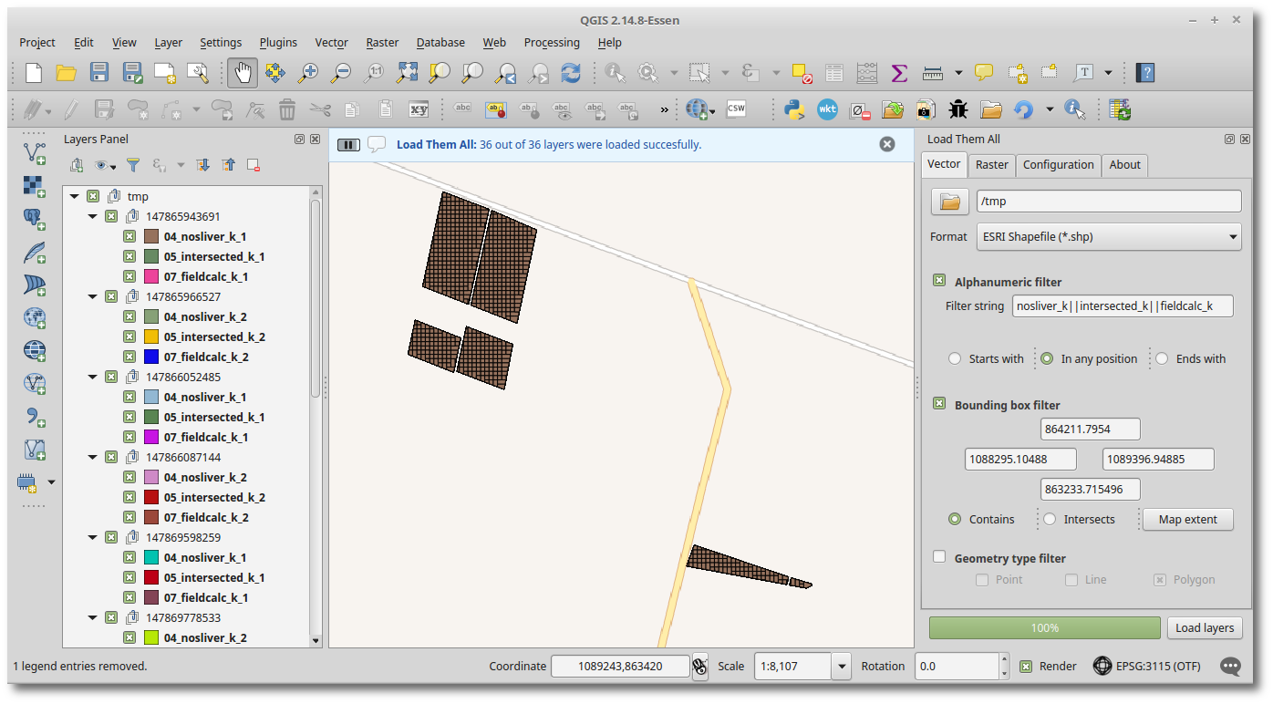
QGIS plugin that recursively loads vector and raster layers stored in a directory structure, based on several filters.
Available filters are:
-
Alphanumeric:
Enter a filter text and choose among the modes 'Start with', 'Any position', or 'Ends with' to find files by name. You can use the logical operators || (or) and && (and), and even combine them. && has more priority, so the expression "a || b && c" becomes "(a || b) && c". Additionally, you can invert the Alphanumeric filter, i.e., prepend a logic NOT to it, allowing you to invert the original filter result.
-
Bounding box:
Enter coordinates by hand or get the current map extent. Choose the spatial filter: 'Contains' or 'Intersects'.
-
Date modified:
Filter files by their latest modification date, using comparisons like 'before', 'after' and 'exact date'.
-
Geometry type:
Choose which geometry type you want to load: 'Point', 'Line', or 'Polygon'.
-
Raster type:
Choose which raster type you want to load: 'Gray or undefined', 'Palette', 'Multiband', or 'Color Layer'.
There are several options for you to configure how layers should be loaded to QGIS:
- Groups: Whether or not to create groups based on directories' names. When groups are created, they reflect the directory structure, i.e., groups are nested if necessary.
- Turn off layers: Make loaded layers invisible (it improves performance).
- Do not load empty layers.
- Sort (or reverse sort) loaded layers.
- Ignore case in the alphanumeric filter.
- Ignore accents in the alphanumeric filter.
The plugin supports the following file extensions:
-
Vectors
- ESRI Shapefile (*.shp)", [".shp"]
- Mapinfo File (*.mif, *.tab)", [".mif", ".tab"]
- Microstation DGN (*.dgn)", [".dgn"]
- VRT - Virtual Datasource (*.vrt)
- Comma Separated Value (*.csv)
- Geography Markup Language (*.gml)
- GPX (*.gpx)
- KML - Keyhole Markup Language (*.kml)
- GeoJSON (*.geojson)
- GMT (*.gmt)
- SQLite (*.sqlite)
- Arc/Info ASCII Coverage (*.e00)
- AutoCAD DXF (*.dxf)
-
Rasters
- Virtual Raster (*.vrt)
- GeoTIFF (*.tif, *.tiff)
- Erdas Imagine Images (*.img)
- Arc/Info ASCII Grid (*.asc)
- Portable Network Graphics (*.png)
- JPEG JFIF (*.jpg, *.jpeg)
- Graphics Interchange Format (*.gif)
- X11 PixMap Format (*.xpm)
- MS Windows Device Independent Bitmap (*.bmp)
- PCIDSK Database File (*.pix)
- PCRaster Raster File (*.map)
- ILWIS Raster Map (*.mpr, *.mpl)
- SRTMHGT File Format (*.hgt)
- GMT NetCDF Grid Format (*.nc)
- GRIdded Binary (*.grb)
- Idrisi Raster A.1 (*.rst)
- Golden Software ASCII Grid (*.grd)
- R Object Data Store (*.rda)
- Vexcel MFF Raster (*.hdr)
- USGS Optional ASCII DEM (*.dem)
- Magellan topo (*.blx)
- Rasterlite (*.sqlite)
- SAGA GIS Binary Grid (*.sdat)
LICENSE: GPL v2.0
Code contributors:
- David Bakeman (v2.1 and v2.4)
- Sören Gebbert (v2.3)
More info about LoadThemAll at http://geotux.tuxfamily.org/index.php/en/geo-blogs/item/264-plugin-load-them-all-para-quantum-gis
See the changelog at https://github.com/gacarrillor/loadthemall/blob/master/changelog.txt