Functions to query the NDBC .
Returns pandas dataframes for the wave parameters.
Data descriptions - [Link][http://www.ndbc.noaa.gov/measdes.shtml ]
The real time data for all of their buoys can be found at:
http://www.ndbc.noaa.gov/data/realtime2/
The realtime data provided is :
File
Description
.data_spec
Raw Spectral Wave Data
.spec
Spectral Wave Summary Data
.swdir
Spectral Wave Data (alpha1)
.swdir2
Spectral Wave Data (alpha2)
.swr1
Spectral Wave Data (r1)
.swr2
Spectral Wave Data (r2)
.txt
Standard Meteorological Data
The data headers for each of the files are provided below.
YY
MM
DD
hh
mm
Sep_Freq
spec_1
(freq_1)
spec_2
(freq_2)
spec_3
(freq_3)
...
YY
MM
DD
hh
mm
WVHT
SwH
SwP
WWH
WWP
SwD
WWD
STEEPNESS
APD
MWD
yr
mo
dy
hr
mn
m
m
sec
m
sec
-
degT
-
sec
degT
YY
MM
DD
hh
mm
alpha1_1
(freq_1)
alpha1_2
(freq_2)
alpha1_3
(freq_3)
...
YY
MM
DD
hh
mm
alpha2_1
(freq_1)
alpha2_2
(freq_2)
alpha2_3
(freq_3)
...
YY
MM
DD
hh
mm
r1_1
(freq_1)
r1_2
(freq_2)
r1_3
(freq_3)
...
YY
MM
DD
hh
mm
r2_1
(freq_1)
r2_2
(freq_2)
r2_3
(freq_3)
...
YY
MM
DD
hh
mm
WDIR
WSPD
GST
WVHT
DPD
APD
MWD
PRES
ATMP
WTMP
DEWP
VIS
PTDY
TIDE
yr
mo
dy
hr
mn
degT
m/s
m/s
m
sec
sec
degT
hPa
degC
degC
degC
nmi
hPa
ft
Method
Description
data_spec
raw spectral wave data
get_spec
spectral wave summaries
get_swdir
spectral wave data (alpha1)
get_swdir2
spectral wave data (alpha2)
get_swr1
spectral wave data (r1)
get_swr2
spectral wave data (r2)
get_txt
standard meteorological data
#Examples
import buoypy as bp
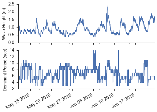
buoy = 41108 #wilmington harbor
B = bp .realtime (buoy ) #wilmington harbor
df = B .txt ()
# plotting
fig ,ax = plt .subplots (2 ,sharex = True )
df .WVHT .plot (ax = ax [0 ])
ax [0 ].set_ylabel ('Wave Height (m)' ,fontsize = 14 )
df .DPD .plot (ax = ax [1 ])
ax [1 ].set_ylabel ('Dominant Period (sec)' ,fontsize = 14 )
ax [1 ].set_xlabel ('' )
sns .despine ()
Historic Data - All information from a buoy All buoys have different years that they are online. This aims to grab all the available data. Currently only grabbing the standard Meteorological data is implemented.
The historic data provided is:
Description
Standard Meteorological Data
YY
MM
DD
hh
mm
WDIR
WSPD
GST
WVHT
DPD
APD
MWD
PRES
ATMP
WTMP
DEWP
VIS
TIDE
yr
mo
dy
hr
mn
degT
m/s
m/s
m
sec
sec
degT
hPa
degC
degC
degC
nmi
ft
import buoypy as bp
buoy = 41108
year = 2014
H = bp .historic_data (buoy ,year )
df = H .get_stand_meteo ()
# plotting
fig ,ax = plt .subplots (2 ,sharex = True )
df .WVHT .plot (ax = ax [0 ])
ax [0 ].set_ylabel ('Wave Height (m)' ,fontsize = 14 )
df .DPD .plot (ax = ax [1 ])
ax [1 ].set_ylabel ('Dominant Period (sec)' ,fontsize = 14 )
ax [1 ].set_xlabel ('' )
sns .despine ()
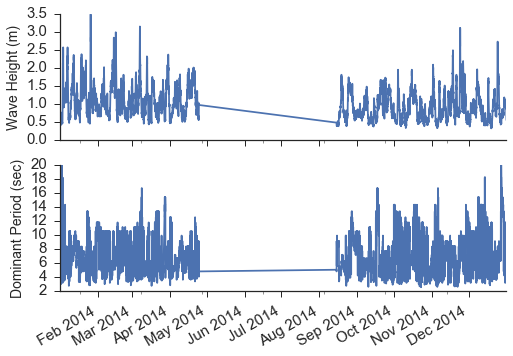
Notice that the buoy went offline from the end of April, 2014 to mid August, 2014.
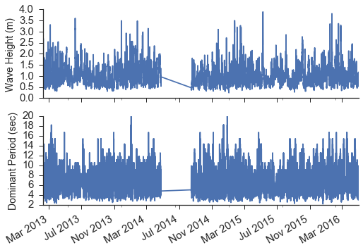
Historic Range - Grab data from a range of years import buoypy as bp
buoy = 41108
year = np .NAN
year_range = (2010 ,2018 )
H = bp .historic_data (buoy ,year ,year_range )
X = H .get_all_stand_meteo ()
#plotting
fig ,ax = plt .subplots (2 ,sharex = True )
X .WVHT .plot (ax = ax [0 ])
ax [0 ].set_ylabel ('Wave Height (m)' ,fontsize = 14 )
X .DPD .plot (ax = ax [1 ])
ax [1 ].set_ylabel ('Dominant Period (sec)' ,fontsize = 14 )
ax [1 ].set_xlabel ('' )
sns .despine ()


