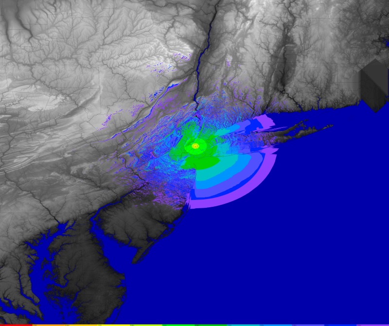
Scripts to run the Splat! radio terrain mapping tool.
This was built and tested on Debian Jessie (8.0) with the following versions:
ii  splat          1.4.0-2       amd64        analyze point-to-point terrestria
ii  bc             1.06.95-9     amd64        GNU bc arbitrary precision calcul
ii  coreutils      8.23-4        amd64        GNU core utilities
ii  imagemagick    8:6.8.9.9-5   amd64        image manipulation programs -- bi
ii  optipng        0.7.5-1       amd64        advanced PNG (Portable Network Gr
ii  sed            4.2.2-4+b1    amd64        The GNU sed stream editor
ii  wget           1.16-1        amd64        retrieves files from the web
ii  unzip          6.0-16+deb8u2 amd64        De-archiver for .zip files
ii  time           1.7-25        amd64        The GNU time program for measuring cpu resource usage
Success was also reported on Ubuntu, FreeBSD, and OpenBSD.
Edit the shell scripts to set the paths for the SDF elevation files and the political borders file.
To download and convert the SRTM data use the get-datafiles*.sh scripts. Go
get some coffee while this runs, it will take a while. After it is completed,
you should be able to run the example profile as below.
If interrupted, the retrieval of the SRTM *hgt.zip files over the network can
be restarted and will resume where it left off.
Note the following disk space requirements to complete the data conversion:
- Africa: 5.4 GB
- Australia: 1.2 GB
- Eurasia: 9.0 GB
- Islands: 92 MB
- North America: 3.6 GB
- South America: 3.3 GB
- All: 23 GB
The *hgt.zip files are not required after conversion, but they are not
removed by the script. They are retained so that a new run may commence
without downloading all the files again from the server. This happens via the
wget -N option.
After removing the *hgt.zip files, disk space required for operations comes
down to:
- Africa: 2.1 GB
- Australia: 434 MB
- Eurasia 3.4 GB
- Islands: 36 MB
- North America: 1.4 GB
- South America: 1.3 GB
- All: 8.5 GB
$ ./splat-radio.sh example.cfg
$ cat example.cfg
NAME="example"
CALL="KQ2H"
LAT="40.7484931946"
LON="-73.9856567383"
HTAGL="373m"
ERP="250"
FREQMHZ="449.2250"
Parameters are as follows:
NAME: used to uniquely name filesCALL: will be labeled onto the mapLAT: latitude, decimal degreesLON: longitude, decimal degrees (East is positive)HTAGL: height above ground level -- without units the default is in feet; use a "m" suffix for meters (e.g. "30" means 30 feet; "10m" means 10 meters)ERP: effective radiated power in Watts -- be sure you take feedline loss and antenna gain into account; enter ERP="0" to produce path loss plotsFREQMHZ: frequency in MHz
Height above average terrain, in feet
These predictions are configured to estimate a simplex contact, with a
receiver station at 2 meters (6 feet), similar to a mobile station. This
is not a valid prediction for access to repeater stations on towers. This of
course can be changed by editing the splat-radio.sh script.
The model does not take reflections and multipath into account.
Defaults were chosen for things like ground permeativity and other parameters. Adjust as needed if your situation warrants it.
- More error checking.
